
An Overview to Backpack Camping on Minnesota's Public Lands
The ability to gather the essentials into a camping kit portable enough to carry on your back is a key to unlock access into more remote and private campsites. You can hike a short 1/4 mile into the woods, further from the crowded car campground to a more secluded campsite. You can get several miles deep into a state or national forest and make camp at a remote private site, or bushwhack through wild lands and locate a natural site of your own choosing. There's camping out of a backpack, and then there's backpacking. When you're up for it; set off on a long distance hiking trail, traveling over multiple days or weeks, spending each night in a new site.
The next seven Ways to Camp on Minnesota's public lands require an approach on foot.
Ways of the Backpack Camper
6


11
10

8

9

7


12
-
Fee. Reservable.
-
Less remote.
-
Rustic amenities; picnic table, fire ring, pit toilet.
-
Free. First come, first served.
-
More remote.
-
Rustic or primitive amenities; cleared tent site, fire ring, pit toilet.
-
Free. First come, first served.
-
More remote.
-
Rustic or no amenities.
6. Backpack Camping in Minnesota State Parks
40 Parks 307 sites ($$) 100% reservable
Minnesota state parks offer multiple camping experiences that require you to carry your camp equipment from the vehicle left at trailhead parking to your site. The state park service calls this remote camping. The extra effort of self sufficient portaging rewards with privacy in solitude. All sites are reservable. On top of the rate per site, per night, there is a vehicle entrance fee to the state parks; $7 per day or $35 for an annual pass.
Walk-In Sites / Cart-In Sites
25 out of 75 state parks and recreation areas offer walk-in or cart-in campsites adjacent to their campgrounds. In total there are ~175 walk-in campsites.
Walk-in sites, some providing wheeled carts for hauling equipment (thus becoming "cart-in" sites), are no more than a 1/4 mile from the trailhead. If you're hauling out all of the gear for an extra comfortable car campout, it's a few trips worth of work for some extra peace and privacy. If you've selected one of these to sample the experience of your first backpacking campout, the hike in will feel a little underwhelming.
These site amenities include tent pads, fire rings, tables, and primitive toilets. Drinking water isn't far away in the nearby car campground but it's best to bring along your own or have the ability to treat a wild source of water. Pack out your trash. All of these sites are reservable. The rates for these sites range from $15 at the more primitive sites to $23 for the ones that are in popular parks adjacent to well developed campgrounds.
* These sites are included in the car camping map, not the backpacking map.
Backpacking Sites
19 out of 75 state parks and recreation areas offer backpacking campsites away from the developed campgrounds. In total there are 132+ backpack campsites.
These sites require an approach distance greater than 1/4 mile. To access these most comfortably and efficiently, proper backpacking equipment and techniques are necessary. These are great introductions to backpacking. You can test your gear and dial in your backcountry kit without serious risk. If you bring too much stuff, the hike hasn't taken longer than a few miles. If you left something important behind in the car, it's a reasonable jaunt back to get it.
These primitive sites include a cleared area with tent pad, fire ring and picnic table. Sometimes there is nearby access to a latrine or firewood. Water must generally be acquired from a wild source and treated accordingly. Pack out your trash. All of these sites are reservable. The rates average around $15 per site, per night.
7. Backpack Camping in Minnesota State Forests
1 Forest 5 sites $Free 0% reservable
While the state forest system maintains many car campgrounds they do not develop many designated dispersed backpack campsites.
Richard J. Dorer State Forest, in the Isinours Management Unit, hosts two hike-in backpack campsites. The approach from the trailhead is less than a half mile. Amenities are primitive and include a cleared tent site, a fire ring and a picnic table. These sites are free and first come, first served.
There are also three hike-in campsites marked on maps for the Reno Recreational Unit. These are very primitive and considerably overgrown with plant life.
There may not be a large inventory of designated sites but consider camping style #12 to unlock more camping in the state forests.
8. Backpack Camping in U.S. National Forests in Minnesota
2 Forests, 18 Trails 51 sites $Free 0% reservable
The eighth way to camp on Minnesota's public lands tests your backpacking ability at the next level. Within either of the two U.S. national forests within Minnesota, you will be selecting campsites and trailheads that are further away from developed infrastructure and services. This remoteness can be private and peaceful, but it also requires a self-sufficient preparedness to handle emergency situations while distant from any services. There is no fee for these sites. You pay with the additional labor of treating your own water, hanging your food away from animals and packing out your trash.
These are single isolated campsites They have a cleared area for a tent, a fire ring, often a picnic table, and a vault toilet. Some can also be reached by boat. There are no reservable sites, all are first come-first served. There is also no entrance fee to enter a national forest. These sites offer overnight vehicle parking at a hiking trailhead.
You can still choose shorter hikes, some less than a mile - but the national forests do offer backpacking trail systems for any difficulty level. These are great opportunities for your first weekend outings as you move towards multi-day backpacking experiences.
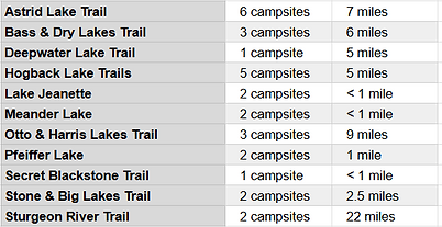
The Superior National Forest has 24 designated backpacking sites on 8 trails.
• These do not include the backpack camping opportunities inside the Boundary Waters Canoe Area Wilderness, a million acre plus section of the Superior National Forest. Backpack camping in the wilderness area is a different camping experience described next.
The US Geological Survey sells large print national forest maps. This is a great resource despite lacking information on these remote backpack camping opportunities. Buy one and marker it up with the campsites found here on Minnesota Camp Guide.
Backpack Camping in the Superior National Forest
8 Trails, 60+ Miles 24 sites ($Free) 0% reservable
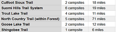
The Chippewa National Forest has 20 designated backpacking campsites on 6 trails.
On the USDA Chippewa National Forest website is a series of dispersed camping maps that includes the campsites below, though the sites do not differentiate between car, backpack and paddle campsites. The digital maps on this site do.
• The Forest Service refers to these as “dispersed camping” sites. They are actually designated and maintained locations. Try not to confuse this language with actual dispersed camping, camp style #12, which is also allowed in this forest.
• 5 of these campsites are on the North Country national scenic trail, a multi-day long distance backpacking experience that runs through the southern edge of the forest. See camp style #10.
Backpacking Trails in the Chippewa National Forest
5 Trails, 137 Miles 20 sites ($Free) 0% reservable
9. Backpack Camping in the Boundary Water Canoe Area Wilderness
1 Wild, 11 Trails 71 sites ($) 0% reservable
Within the Superior National Forest is the million acre plus Boundary Waters Canoe Area Wilderness. A geography of densely forested rock and intricately connected waterways is most often explored by canoe. This wild and remote landscape can also be experienced on foot, with the necessary gear in your backpack, in the way of camp #9.
These sites are primitive and isolated, including a cleared area for a tent, a fire ring and a vault toilet. Some can also be reached by boat. Water is treated from a natural source, food kept away from animals and all trash must be packed out.
To limit the number of people entering and impacting the wilderness, a $16 permit is required to enter the wilderness area between May 1 and September 30. There are a limited number of permits available to each trailhead. You must camp at the designated sites, and may not dispersed camp elsewhere. These sites are not reservable and are first come, first served.
The Boundary Waters Canoe Area Wilderness includes 71 designated backpacking sites on 11 trails.
Some trails make short, piercing forays from the edge of the wilderness, offering overnight excursions and great options for first-time experiences of wilderness area backpacking. Some trails embark on multi-day loops around large lakes or make the ambitious goal of traversing the entire wilderness.
Shorter Overnight Backpacking Trails in the B.W.C.A.
5 Trails, 45 Miles 13 sites ($) 0% reservable

Longer Multi-Day Backpacking Trails in the B.W.C.A.
5 Trails, 197 Miles 61 sites ($) 0% reservable

Several of these are described below. The others are sections of the national scenic trail described next in Way to Camp #10.
The Pow Wow Trail Backpacking Sites
This 32 mile loop trail includes 6 backpacking campsites.
The Pow Wow Trail is a primitive trail that receives very little clearing maintenance. Lots of blown down trees and overgrowth make this a very challenging trail to navigate. Advanced map and compass skills and reliable GPS data are necessary to hike this trail safely and comfortably. The Forest Service only recommends the use of a 5 mile, minimally maintained eastern section that runs from the trailhead to Pose Lake Campsite. The remainder is unmaintained. For the experienced backpacker who can access these remote sites, the reward is solitude, scenery and abundant wildlife.
The sites are primitive, offering basic shelter to backpackers, and may be shared by paddlers, though many are distant from canoe routes. Cleared spaces for tents , a fire ring, communal cooking area and a pit latrine are to be expected. Nearby natural sources of water must be treated accordingly. Prepare to animal proof your food package, hang your food at night and pack out everything you bring in. The sites are first come - first served and are free of charge. This trail is very lightly trafficked.
Since you are entering the Boundary Waters Wilderness Area, a $16 entry permit is required May 1 - Sep 30.
The Sioux Hustler Trail Backpacking Sites
This 30 mile loop trail includes 7 backpacking accessible campsites.
The Sioux Hustler is a very primitive trail and is notoriously difficult to maintain. Overgrown singletrack bedeviled by the blowdown and burning of strong winds and forest fire events make this a very challenging trail to navigate. Advanced map and compass skills and reliable GPS data are necessary to hike this trail safely and comfortably. For the experienced backpacker who can access these remote sites, the reward is solitude, scenery and abundant wildlife.
The sites are primitive, offering basic shelter to backpackers, and may be share by paddlers. Cleared spaces for tents , a fire ring, communal cooking area and a pit latrine are to be expected. Nearby natural sources of water must be treated accordingly. Prepare to animal proof your food package, hang your food at night and pack out everything you bring in. The sites are first come - first served and are free of charge. This trail is very lightly trafficked.
Since you are entering the Boundary Waters Wilderness Area, a $16 entry permit is required May 1 - Sep 30.
The Snowbank Lake Trail Backpacking Sites
This 24 mile loop trail includes 10 backpacking accessible campsites.
The Snowbank Lake Trail hosts moderate foot traffic, more so than the previous two trails mentioned. This very scenic hike loops around the large, and quintessentially characteristic Snowbank Lake, rolling up and down rock and pine terrain at an intermediate to low difficulty hiking level. It suffers from storm damage from time to time, but is located such that it sees sooner maintenance from volunteer trail crews.
The sites are primitive, offering basic shelter to backpackers, and may be shared by paddlers. Cleared spaces for tents , a fire ring, communal cooking area and a pit latrine are to be expected. Nearby natural sources of water must be treated accordingly. Prepare to animal proof your food package, hang your food at night and pack out everything you bring in. The sites are first come - first served and are free of charge.
Since you are entering the Boundary Waters Wilderness Area, a $16 entry permit is required May 1 - Sep 30.
Several shorter trails loop off and offer additional access to campsites. These trails include;
-
The 12 miles of the Old Pines / Disappointment Mountain Trail loops with 4 backpacking campsites .
-
The 1.5 mile Benezie - Becoosin Lakes Loop with 4 backpacking campsites.
10. Backpack Camping on a National Scenic Trail
1 Trail (or 4), 596 Miles 147 sites ($) 0% reservable
The tenth way to camp on Minnesota public lands is by multi-day backpacking on the lengths of trail that make up the North Country National Scenic Trail. The main goal here is to combine wild and remote camping experiences with the more primary pursuit of covering ground on long distance hiking treks. These sites are intended for single night stays before moving on.
The sites are primitive, offering basic shelter to backpackers. Cleared spaces for tents , a fire ring, communal cooking area and a pit latrine are to be expected. Nearby natural sources of water must be treated accordingly. They are first come - first served and are free of charge.
Some of these trails are located within the Boundary Waters Canoe Area Wilderness Area, thus an entry permit is required.
Understanding the landscape of long distance hiking paths in Minnesota can be confusing. As simply put as possible...
There is the officially recognized North Country National Scenic Trail corridor, crossing the northern third of the state. The actual trail that will one day travel this corridor, is still under development. There is a major section of the NCT complete in the northern center of MN as it travels through the Chippewa National Forest. Between there and the Arrowhead region, the trail does not yet exist on the ground.
In the Arrowhead region, in the Boundary Waters Wilderness, within the Superior National Forest - is the first of three other long distance hiking trails that have existed in place before being co-opted and included into the North Country Trail route. These three trails end where another begins. The Kekekabic, Border Route and Superior Hiking Trails cover a long distance traverse through the Boundary Waters Wilderness and along the entirety of Minnesota's Lake Superior shoreline.
While this perspective helps organize the mind, each of these four trail entities should be considered separately; for their individual characters & experience, and for the non-profit organizations who manage them in partnership with private and government landowners. Each of these desire more hikers, more volunteers and more donor contributions to help steward their section of trail experience.

The North Country Hiking Trail Backpacking Sites
The North Country National Scenic Trail is a congressionally recognized 4,600 mile footpath running from central North Dakota to eastern New York. Much of the trail is under development. The trail route enters Minnesota on the western border south of Fargo/Moorhead then trends northeast through the Chippewa National Forest and up to Ely and the Superior National Forest. Here it co-opts the trails mentioned above, the Kekekabic then the Border Route then the Superior Hiking Trail, heading south along the Lake Superior shore where it enters Wisconsin at Jay Cooke State Park. Outside of these previously mentioned trails above, there is one other completed continuous section.
This 180 mile section runs between Detroit Lakes and Remer and includes 24 backpacking campsites.
There is lots of access to this trail and it's camping as it winds through state park, state forest and national forest. The sites are primitive, offering basic shelter to backpackers. Cleared spaces for tents , a fire ring, communal cooking area and a pit latrine are to be expected. Nearby natural sources of water must be treated accordingly. They are first come - first served and are free of charge.
On this section of the NCT dispersed camping outside of the 24 designated backpacking campsites is generally allowed except within Itasca, Greenwater Lake Scientific and Natural Area, and Tamarac National Wildlife Refuge.
The Kekekabic Hiking Trail Backpacking Sites
This 40 mile hiking trail includes 11 backcountry campsites.
The Kek travels from a western terminus at a trailhead south of Snowbank Lake, about 20 miles down the road from the city of Ely, to an eastern terminus on the Gunflint Trail (County Road 12) where it connects to the Border Route Trail. The trail is a primitive, remote and rugged experience, piercing the heart of the Boundary Waters Canoe Area Wilderness.
Sites are first come - first served and visitation is low. Amenities include cleared, level tent spaces, fire rings with steel cooking grates and a pit toilet. Water must be treated from a wild source. There is no road or trail access between the two ends as the trail crosses many miles of uninterrupted wilderness. Map and compass navigation skills and/or GPS data and devices are highly recommended. Most of these sites are lakeside, and may also be used by paddlers. Otherwise they are accessed only by committing to a thru-hike. If your hike on a given day doesn't end with you at one of the designated campsites, you can dispersed camp anywhere at least 150 feet off the trail.
Since you are traversing the Boundary Waters Wilderness Area, a $16 entry permit is required May 1 - Sep 30.
The Border Route Hiking Trail Backpacking Sites
This 65 mile hiking trail includes access to 18 backcountry campsites.
The BRT western terminus is on the Gunflint Trail (County Road 12), where it connects with the Kekekabic. It travels east, traversing pristine conifer woods and glacial waters of the Boundary Waters Canoe Area Wilderness a stone's throw from the Canadian border and along a popular, historic indigenous and voyageur paddling route before reaching it's eastern terminus at the Swamp River, meeting the northern terminus of the Superior Hiking Trail. It is a more primitive and remote backpacking experience than the nearby SHT, but overcoming these challenges embeds the outdoorist in the wildest portion of the state.
Sites are first come - first served and visitation is low. Amenities include cleared, level tent spaces, fire rings with steel cooking grates and a pit toilet. Water must be treated from a wild source. Major road access is at the beginning and at the end, with many miles of uninterrupted wilderness in between. Map and compass navigation skills and/or GPS data and devices are highly recommended. Most of these sites are lakeside, and may also be used by paddlers. Otherwise they are accessed only by committing to a thru-hike. If your hike on a given day doesn't end with you at one of the designated campsites, you can dispersed camp anywhere at least 150 feet off the trail.
Since you are traversing the Boundary Waters Wilderness Area, a $16 entry permit is required May 1 - Sep 30.
The Superior Hiking Trail Backpacking Sites
This 310 mile hiking trail includes 94 backcountry campsites.
Minnesota's most popular long distance hiking trail; the SHT runs along the heights of the Sawtooth Mountains on the North Shore of Lake Superior. The northern terminus at the Canadian border meets the Border Route Trail, which heads deeper in the BWCA wilderness and the southern terminus ends near Duluth, at the Wisconsin border adjacent Jay Cooke State Park.
It is well signed, fairly easy to navigate and thus a great trail for first time backpackers. There is frequent access to the trail from Highway 61 and the county roads that run from it. As the trail crosses the many rivers and streams that drain the North Shore watershed, the hiker is gifted with interesting topography, scenic overlooks and ample sources to filter water.
The trail supports several different backpack camping experiences. When there is high demand for other North Shore campgrounds, it is possible to park at an SHT trailhead and hike into a backcountry site instead. Private shuttle services run the length of the trail, supporting weekend or multi day hikes or you can pursue the achievement of a full thru-hike, completing the entire trail distance in three to four weeks.
There are no permits and no fees. You must camp at designated campsites, dispersed camping is not allowed. Campsites are first come - first served and hikers accommodate one another by sharing communal camp space. Having company at camp is not unexpected in the summer. Be prepared to treat natural water, hang your food away from animals and pack out everything you pack in.
11. Backpack Camping in US National Parks in Minnesota
Voyageurs 1 National Park 2 sites ($)
Virtually all of Voyageurs National Park 150+ backcountry campsites require watercraft to access. Fifteen of these sites are inland on small lakes within the Kabetogama Peninsula landmass. These are portage and paddle experiences and are covered in greater detail in way to camp #18.
Voyageur’s is also home to the 28 mile Kab-Ash Hiking Trail, which includes two backpacking campsites. One of the few ways to experience this park without watercraft, these primitive amenity campsites are inexpensive and require reservation.
Grand Portage 1 National Monument 2 sites $Free
Grand Portage National Monument is less a national park unit with a backpacking trail than it is a backpacking trail that is a national park unit. This nine mile length of historically significant track in the northeastern tip of Minnesota was the link for indigenous and voyageur canoe paddlers between Lake Superior, the Pigeon River and all inland waterways beyond. Besides other park attractions, hiking this distance leads to a unique camping experience deep back in woods and time.
The Fort Charlotte campsites feature raised platform tent pads that accommodate up to 9 people. Outhouse, picnic tables and fire rings round out the amenities at this unique space on the banks of the Pigeon River. Check availability and apply for a free overnight permit with the NPS.
12. Dispersed Backpack Camping in State and National Forests
7.7 Million + Acres ∞ sites $Free
Bushwhacking, tramping, the old school.
The 12th way to camp on Minnesota public lands is by hiking your gear into undeveloped wilds, on foot.
Dispersed camping happens in the general forest area, outside of designated sites. You may set up camp anywhere so long as you are not within 150 feet of roads, trails, water bodies or other designated campsites. There is no infrastructure of any kind. It is your responsibility to safely and responsibly locate a shelter site, treat your own water, keep your food away from animals, dispose of and pack out your waste and leave no evident trace of your visit.
State forests and national forests in Minnesota include more than 2,000 miles of roads. Find a place to park your vehicle. You are not allowed to park motor vehicles anywhere it may impede traffic, harm vegetation or soils. It's not too much of a challenge to achieve this. From here, throw on your pack and explore the untamed backcountry of over 7.7 million acres of state and national forests. Our wilderness is thick with forest, waterways and wetland, so don't expect to bound across untrammeled miles of wild space. But explore a map for opportunities. This way of camping might afford a one of a kind camp for the explorer who can navigate their way along a river or through the woods to a particular camp friendly geographic feature. Practice proper backcountry ethics and leave no trace of your visit.
-
US National Forests in Minnesota have the same rules.
01-05
06-12
13-16
17-23


